An electrified barbed-wire fence winds through the western Himalayas, dividing what was once the princely state of Jammu and Kashmir from 1846 to 1947. Now, the land on the west side of the fence is controlled by Pakistan; the east, by India. (Another section in the northeast is under Chinese control.)
The fence marks the Line of Control, a militarized barrier about 767 km (477 miles) in length that divides the two nuclear powers. Three of the multiple serious conflicts or all-out wars that Pakistan and India waged against each other in the last 72 years since both gained independence were directly fought over it. (Read our coverage of communities near the Line of Control here.)
About three-quarters of the line is covered in barbed wire, much of which is electrified, says Pawan Bali, a conflict resolution expert with experience in India-Pakistan issues. Lasers are used to detect anything that crosses unfenced sections, while landmines, tunnel detection gadgets and military outposts are strewn along the barrier.
From 1949 to 1972, the line was referred to as the“ceasefire line.”In 1972, India and Pakistan agreed to change the name toLine of Control– an alleged attempt by India to keep United Nations peacekeeping forces from monitoring the area.


Even so, about 115 UN peacekeepers remain there to monitor the line, which neither India nor Pakistan recognizes as a legal international boundary. Eleven peacekeepers have already been killed in that operation.
Violations of the various ceasefire agreements between India and Pakistan are common and on the rise. Even so, both militaries have established tools of cooperation, including a hotline between the two countries’ director generals of military operations. Sector commanders, too, have regular meetings.
Highly-coordinated events known as flag meetings are held regularly between the two countries at the line. The choreographed events are full of pomp, designed to allow both militaries to exhibit precise showmanship. Crowds gather to cheer each side on in a festive atmosphere that belies the deadly violence occurring elsewhere.
Not all sections of the Line of Control are fenced. Some sections have natural barriers such as rivers, marshes or glaciers, and are widely recognized among locals, says Bali.
“When you go to Poonch, one of the villages near the Line of Control, you can look across the village and say, ‘Beyond that tree is Pakistan,’” Bali says.

The line separates families who were able to move freely through the area before it was drawn. A cross-border bus service operates on a limited basis, but that’s suspended whenever hostilities flare up.
“There’s a Pakistani side and an Indian side, and they stand on the bank of a river and wave to each other,” Bali says. “Then people write letters, tie them to a stone and throw them across.”
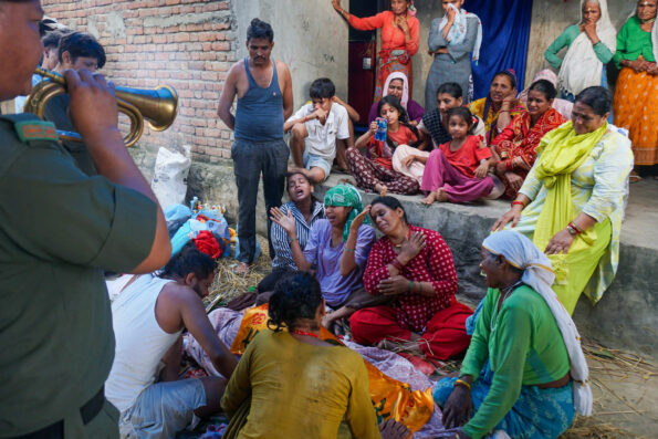
On another occasion, Bali says she saw a funeral during which people from both sides gathered to mourn on the river banks. But they could not cross to console each other.