Editorial Team
Publication Date
August 14, 2023

Coraly Cruz Mejías, GPJ Puerto Rico
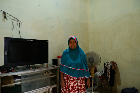
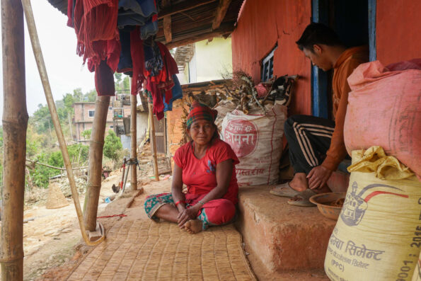
Ramonita Méndez looks at a picture of the sea on her phone, near her home in Tablonal, an area affected by flooding from the Culebrinas River.
AGUADA, PUERTO RICO — Around what used to be a booming sugar mill, generations of families have thrived next to a river and the vast sea. Those times are still vivid in the memory of Nicolás Acevedo Torres, 80. “I’d collect the lunches house by house to take to Coloso [the sugar mill] and put them on the corner before going back to school,” he says happily, as he gives a tour of his garden.
Since the arrival of hurricane season in June, rain has increased while happiness has decreased. Residents’ anxiety and unease escalate with the memory of Hurricane Maria, which destroyed Puerto Rico in 2017 and went down in history as the region’s most devastating storm. The threat of flooding from hurricanes, and the resurgence of a United States Army Corps of Engineers mitigation project to prevent it, worries residents who believe it will damage the ecosystem.
“Every time this bad weather begins, everyone’s on edge,” says Acevedo Torres, referring to the rainy season. “I expect flooding.”
The Culebrinas River flows from the hills and runs 37 miles (60 kilometers), until it settles into a watershed between the municipalities of Aguada and Aguadilla, on the western coast of Puerto Rico. Rain dominates the climate until December, causing the river to swell. In the past, it’s flooded more than 1,500 acres (607 hectares) of land, including communities with major roads, highways and more than 1,000 residents.
For centuries, locals have learned to live with this flooding, but climate change has put them on high alert, especially after Hurricane Maria.


“I’m traumatized,” says surveyor Julio César Cajigas, who lost all of his belongings when the storm surge flooded his house in 2017. “You want to push it from your mind, but everyone was affected by it.”
In 2022, the federal Congress authorized a budget of almost 26.5 million U.S. dollars so that the USACE could restart a mitigation project to control flooding from the Culebrinas River. Approved in 2000, the project has lain dormant until now.
At the time, “people agreed that the project should move forward,” says Olga Vega, a teacher from the Espinar neighborhood, which is at major risk because of its proximity to the ocean. More than two decades since the original proposal, residents now demand updated environmental impact studies and for the project to guarantee “environmental justice.” The current proposal, Vega says, “is a monster.”
The USACE project will build two 2.05-mile (3.3-kilometer) levees spanning 23 feet (7 meters) in the middle of a nature reserve known as Caño Madre Vieja, a wetland channel with natural cycles that discharge river water and retain seawater. The goal is to prevent flooding for some 800 residences, 100 businesses and 24 public buildings, including a church founded in 1525.

This project, however, will only help some of those affected by flooding. Tablonal, where Acevedo Torres and Cajigas live, faces an uncertain future. Though it sees flooding three to four times a year, Tablonal has been left out of the mitigation project due to a lack of funds. However, the USACE says that it plans to extract some sand for the project from Tablonal’s sand quarry, even though Tablonal does not have a sand quarry.
Global Press Journal requested an interview with the USACE to clarify where the sand would come from, among other questions, but the request was denied. The Corps of Engineers addressed the question of the sand quarry in a written statement: “Although this report is one of the latest reports for the project completed before it went on pause in 2020, we are currently in a study phase.” Residents are worried that the sand will come from the beaches, as has occurred during past construction projects. As a result, the community fears that mitigating floods for their neighbors in Espinar will end up aggravating their own problems.
Urban planner Pedro Cardona Roig believes it is necessary to evaluate the impact in all areas “because you might be resolving the flooding from the river and exacerbating the flooding from ocean swells by eliminating coastal barriers,” like the sand necessary for the project.

Ana Navarro Rodríguez, a coastal ecosystems specialist with the Sea Grant Program at the University of Puerto Rico’s Mayagüez campus, has advised the community for two decades and believes the project could cause irreparable harm.
The construction will disrupt the wetlands and the mangroves of the Caño Madre Vieja, and the levees could disperse the accumulated water toward the inhabited valleys, Navarro says.
“If the levees are placed there, then a constant seawater inflow will occur. This doesn’t happen at this time of year. Seawater comes in, but it’s balanced because the Caño [Madre Vieja] closes and opens in different areas, keeping [the seawater and fresh water] in balance,” Navarro says. “If this canal is left open, the estuary’s salinity will be extremely high. It will completely change the ecosystem. They will destroy it.”
The USACE’s environmental studies date back to 2004. After complaints from residents, they were updated in 2020. In those studies, the USACE recognizes that 10 acres (4 hectares) of wetlands in the old sugar cane fields would inevitably be affected but assures that they will be replaced with another 12 acres (almost 5 hectares) of wetlands. The USACE also told Global Press Journal in a written statement that it will conduct hydrological and hydraulic studies. “This new field data will help us validate and refine the project design, as well as the different aspects related to wetlands, real estate acquisition, and engineering with nature initiatives.”

Tablonal resident Ramonita Méndez’s voice trembles when she speaks of the possible consequences of the mitigation project in her neighborhood, where there are more than 300 homes. “It’s a complete bulldozing of the community,” she says. “It doesn’t protect us at all.”
Though, until now, they have been left out of flood control consideration, residents of Tablonal fear expropriation by the project’s local sponsor, the Department of Transportation and Public Works. It’s still too early to know which houses will be expropriated. This lack of information fills residents with anguish.
A USACE report states that between 2027 and 2030, the Department of Transportation and Public Works must relocate “installations and public services.” It also identified, using only Google Earth, at least nine houses and two businesses to relocate. An in-person evaluation, however, could demonstrate that more structures should be relocated, the report admits.

“We feel both abandoned and betrayed, as nobody has stood up for us regarding this situation,” says Gloria Aquino, 62, about the possibility of losing her home in Tablonal, as she did in 2017. “I feel a little scared but try not to think about it too much. It can make you sick,” she says. With every flood alert, she takes refuge in her daughter’s house. “Even though I have someplace to go, it’s not easy. Everything could be damaged when I get back.”
Residents recognize that they live in a risky environment. The construction in the valley, the waste that goes down the river, tidal waves and coastal erosion all paint an increasingly complicated picture. The ecosystem is not the same as when they moved here decades ago, and they’re asking for solutions that consider those facts.
The USACE claims that they’ve considered other options, such as channel maintenance or retention walls, but their studies indicate that the levees will offer more effective protection in the long run. In the meantime, residents try not to drown in their feelings of unease and demand alternatives that will allow them to preserve both their homes and the surrounding nature. “Living here is worth it,” Vega says. “We live in a paradise.”
Coraly Cruz Mejías is a Global Press Journal senior reporter based in Puerto Rico.
TRANSLATION NOTE
Sarah DeVries, GPJ, translated this story from Spanish.